Short Answer
Andrew Jackson’s defensive line at New Orleans was a fortified earthwork constructed along the abandoned Rodriguez Canal on Chalmette Plantation, about six miles southeast of New Orleans. Built during the final weeks of December 1814, it served as the principal American barrier against a British invasion force intent on capturing the city and gaining control of the Mississippi River. The line’s successful defense on January 8, 1815, produced a crushing American victory that, although fought after the Treaty of Ghent had been signed but not yet ratified, became a defining moment of the conflict and cemented Jackson’s national reputation.
Historical Context
By late 1814, the War of 1812 had reached a stalemate. With Napoleon’s defeat in Europe, Britain was able to transfer veteran troops to North America and launch an ambitious three-pronged offensive. One prong targeted New Orleans, the gateway to the Mississippi River and the vast Louisiana Purchase. British leaders hoped that seizing the city would sever the western United States from the eastern seaboard, disrupt American trade, and strengthen Britain’s negotiating position at the Ghent peace talks. The British Gulf Coast expedition assembled roughly 8,000 troops—many of them Peninsular War veterans—under Major General Sir Edward Pakenham, the brother-in-law of the Duke of Wellington.
Major General Andrew Jackson, already renowned for his defeat of the Creek Nation at Horseshoe Bend, learned of the British threat in September 1814 and rushed to defend New Orleans. He faced the challenge of protecting a city with many possible approaches, including Lake Borgne, Lake Pontchartrain, and the Mississippi River. After British forces landed on December 23 and advanced to within nine miles of the city, Jackson launched a surprise night attack that temporarily checked their progress. He then withdrew to a naturally defensible position at the Rodriguez Canal, a former millrace that ran from the Mississippi eastward to an impassable cypress swamp. Using this canal as a ready-made trench, Jackson ordered his troops to construct an earthwork rampart.
What Happened
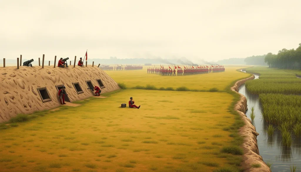
Construction of the line began on December 24, 1814, and continued under difficult conditions of cold and rain. Using slave labor and soldiers, Jackson’s men widened the canal into a defensive ditch and piled the excavated earth into a parapet that in most places reached a height of five to seven feet and was thick enough to resist enemy cannon fire. They lined the parapet with fence rails and timber to stabilize the soil. The line extended approximately 815 toises—about one mile—from the riverbank to a dense swamp. The right flank anchored on the levee and a road; the left faded into the cypress swamp, making a flanking maneuver impossible. Artillery batteries were placed at strategic intervals, including a two-gun battery near the river and a 24-pounder on the right, while light infantry and riflemen, including Tennessee and Kentucky militia, free men of color, and Baratarian privateers under Jean Lafitte, manned the breastwork.
British forces first tested the line on December 28 with a reconnaissance-in-force and again on New Year’s Day with an artillery bombardment, but American gunners held. Pakenham planned a full-scale assault for January 8, 1815, intending to cross a force to the west bank of the Mississippi to silence the American guns there while launching two main columns against the line’s left and right. However, the west bank crossing was delayed, and on the east bank the 44th Regiment, charged with carrying fascines and ladders to cross the canal, moved forward without them. At dawn, British infantry advanced in dense columns across open ground. The American artillery opened fire with round shot and canister, then musketry and rifles poured a lethal fire. The British attack was broken before it reached the parapet. Pakenham was killed by grapeshot, and his two senior generals were also struck down. Within about forty minutes, the British withdrew, leaving the line intact.
Why It Matters
The defensive line’s immediate effect was the decisive defeat of the British assault on January 8, 1815. British casualties totaled 291 killed, 1,262 wounded, and 484 captured or missing; American losses were only 13 killed, 39 wounded, and 19 missing. The victory secured New Orleans and the Mississippi River, and it gave Americans their greatest land triumph of the war. Although the Treaty of Ghent had already been signed on December 24, 1814, its ratification in February 1815 meant the battle had no direct influence on the treaty terms. Nevertheless, at the time Americans believed the victory had forced Britain to make peace, and the battle became a powerful national myth. Jackson’s line and the battle were celebrated for decades as proof of American military prowess, elevating Jackson to a national hero and eventually the presidency. For historians, the line illustrates the importance of prepared defensive positions, the effectiveness of a mixed force of regulars and militia, and the tactical errors that plagued the British assault. The battle also had lasting consequences for the Gulf Coast, including the integration of free black soldiers and the use of privateers in the American cause.
Historical Map Context
Contemporary maps of the battle, most notably those by Arsène Lacarrière Latour, a French-born engineer who served as Jackson’s principal engineering aide, show the defensive line in detail. Latour’s map from his 1816 memoir depicts the Rodriguez Canal, the earthwork with its artillery batteries, the road to New Orleans, and the surrounding swamp. These maps are essential for understanding how the line’s natural and engineered features created a funneling kill zone for the British. Modern visitors can study the same terrain at Chalmette Battlefield, where the trace of the line and the canal are still visible.
Modern Location
The defensive line is located at Chalmette Battlefield and National Cemetery in Chalmette, Louisiana, roughly six miles east of New Orleans. Administered by the National Park Service as part of Jean Lafitte National Historical Park and Preserve, the site includes a reconstructed segment of the earthwork, along with a visitor center and the Chalmette National Cemetery. The battlefield’s coordinates are approximately 29.9399° N, 89.9947° W.
Events at the Site
In addition to the main battle on January 8, 1815, the site saw earlier skirmishes, including the artillery duel on January 1, when British guns fired on the line. The construction itself, from December 24 through January 8, was a continuous activity under enemy observation. The line was never breached during the battle, and after the British withdrawal it remained occupied for a time before being abandoned. Later, the battlefield became a place of national commemoration, and the site was designated a National Historic Landmark in 1960.
Associated People
Key figures associated with the line include Major General Andrew Jackson, the American commander whose tactical foresight placed the line along the Rodriguez Canal; Arsène Lacarrière Latour, the engineer who described the line in detail; and Lieutenant General Edward Pakenham, who led the British assault and was killed at the battle. Other notable participants included Jean Lafitte, who provided intelligence and artillerymen, and the many anonymous soldiers, free men of color, militia, and enslaved laborers who built and defended the line.
Surviving Monuments and Site
The Chalmette Battlefield preserves the memory of the line. A reconstructed section of the earthwork, complete with artillery positions, stands near the visitor center, and a monument commemorates the American victory. The site also includes the Chalmette National Cemetery, where Union soldiers from the Civil War are buried, and a series of interpretive markers explain the battle’s course. A separate monument, the Jackson Monument, honors the general. These features allow modern visitors to visualize the defensive line and the terrain that made it formidable.
Primary Sources
Arsène Lacarrière Latour’s “Historical Memoir of the War in West Florida and Louisiana in 1814–15” (1816) is the most detailed contemporary account of the line’s construction and the battle. Latour served as an engineer on Jackson’s staff and included maps and precise measurements. Another important primary source is Jackson’s official report to Secretary of War James Monroe, dated January 9, 1815, which describes the battle and praises his troops. British reports, including those from Lieutenant Colonel John Keane, survive, though they often downplay the defeat. The Latour memoir and its maps are available at the Library of Congress. These sources are invaluable but represent American and British official perspectives, and their casualty figures sometimes differ from later scholarly compilations.
Further Reading
- Robert V. Remini, “The Battle of New Orleans” (1999).
- Donald R. Hickey, “The War of 1812: A Short History” (1995).
- Robin Reilly, “The British at the Gates: The New Orleans Campaign in the War of 1812” (1974).
- Arsène Lacarrière Latour, “Historical Memoir of the War in West Florida and Louisiana” (1816), original edition.
- National Park Service, “Chalmette Battlefield and National Cemetery” interpretive guide.
References
- “E Pluribus, Unum: The American Battle Line At New Orleans, 8 January 1815,” The Army Historical Foundation, https://armyhistory.org/e-pluribus-unum-the-american-battle-line-at-new-orleans-8-january-1815/.
- “War of 1812: ‘To Describe Those Lines’,” American Battlefield Trust, https://www.battlefields.org/learn/primary-sources/war-1812-describe-those-lines.
- “Battle of New Orleans: War of 1812 & Andrew Jackson,” HISTORY, https://www.history.com/articles/battle-of-new-orleans.
- “Battle of New Orleans – War of 1812,” https://thewarof1812.org/battles/battle-of-new-orleans/. (Data from Hickey, Lambert, Latimer.)
- “The Battle of New Orleans (January 8, 1815),” Bandy Heritage Center, https://www.bandyheritagecenter.org/Content/Uploads/bandy/files/1812/The%20Battle%20of%20New%20Orleans%20(January%208%2C%201815).pdf.
FAQ
Why was the line built along the Rodriguez Canal?
Jackson chose the Rodriguez Canal because it provided a ready-made trench running perpendicular to the Mississippi River, with an impassable cypress swamp on the left flank. This funneled any British attack into a narrow, open field covered by American artillery and musketry.
What was the line made of?
The line was an earthen parapet built from soil excavated from the canal, reinforced with fence rails and timber, and topped with sod. It was thick enough to stop cannon balls and high enough to protect defenders, with a banquette step for firing.
Did the battle affect the Treaty of Ghent?
No. The Treaty of Ghent had been signed on December 24, 1814, two weeks before the battle, but its ratification occurred in February 1815. The battle had no influence on the treaty terms, though many Americans at the time believed it did.

Leave a Reply